
The Sanborn Map® Collection consists of a uniform series of large-scale detailed maps depicting the commercial, industrial, and residential sections of cities. The maps were designed by surveyor D.A. Sanborn in 1866 to assist fire insurance agents in determining the degree of hazard associated with a particular property.
Sanborn Maps® illustrate in outline form the site, size, shape, construction and building material of dwellings, commercial buildings, and factories. Details of buildings include fire walls, the location and number of windows and doors, style and composition of roofs, wall thickness, cracks in exterior walls, and makes of elevators. The maps also indicate building use, sidewalk and street widths, layout and names, property boundaries, distance between buildings, house and block numbers, location of water mains, hydrants, piping, wells, cisterns, and fuel storage tanks.
Library of Congress, Geography and Map Division, Sanborn Maps Collection.
Sanborn Fire Insurance Map from Nantucket, Nantucket County, Massachusetts. Sanborn Map Company, Oct, 1887. Map. https://www.loc.gov/item/sanborn03800_001/.
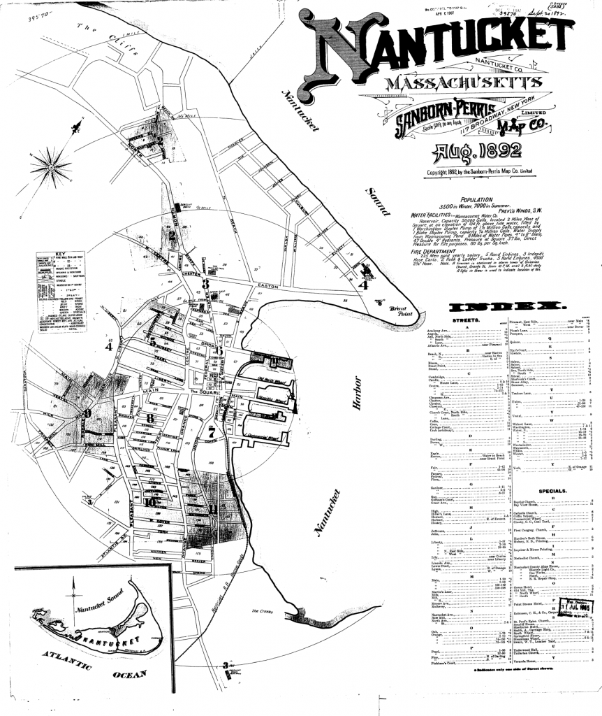
Sheet 1 – Index
Index to Sanborn Maps of Nantucket 1892.
Index of Sanborn maps of Nantucket, 1892Population 3500 in winter, 7000 in summer. Prevaling winds S.W. WATER FACILITIES. Wannacomet Water Company. Reservoir capacity 50,000 gals located 2 miles west of square at an elevation of 100 ft of above tide water, filled by 1 Worthington Duplex Pump of 1 ½ million gals capacity and 1 Blake Duplex Pump, capacity ½ million gals water supply from Wannacomet Pond. 8 miles of water pipes. 4” to 8” diam 47 double 4” hydrants. Pressure at square 37 lbs, direct pressure for fire purposed. 80 lbs per sq inch. FIRE DEPARTMENT 225 men paid yearly salary. 5 hand engines, 3 independent hose carts, 2 hook and ladder trucks, 5 hand engines. 4500 2 ½” hose. Note: A fireman is stationed in alarm tower of Unitarian Church, Orange Street, from 10 PM until 6 AM daily. A light in tower is used to indicate location of fire.
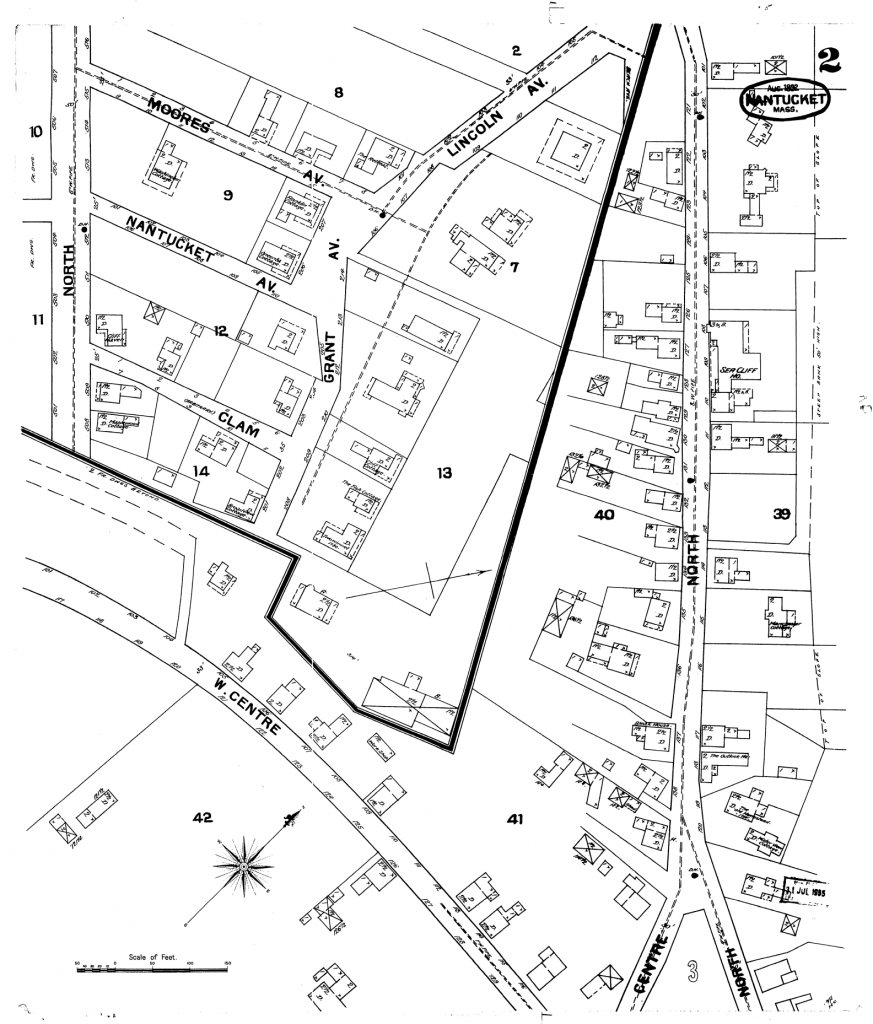
Sheet 2
Map of Nantucket, 1892.
North Street (Cliff Road), Moores Avenue, Nantucket Avenue, Clam Street (Cabot Lane), Grant Avenue, Lincoln Avenue. Also North Street (Cliff Road), West Centre Street (West Chester Street), Centre Street, unnamed (Wyers Lane & Kite Hill Lane). Features include Sea Cliff House.
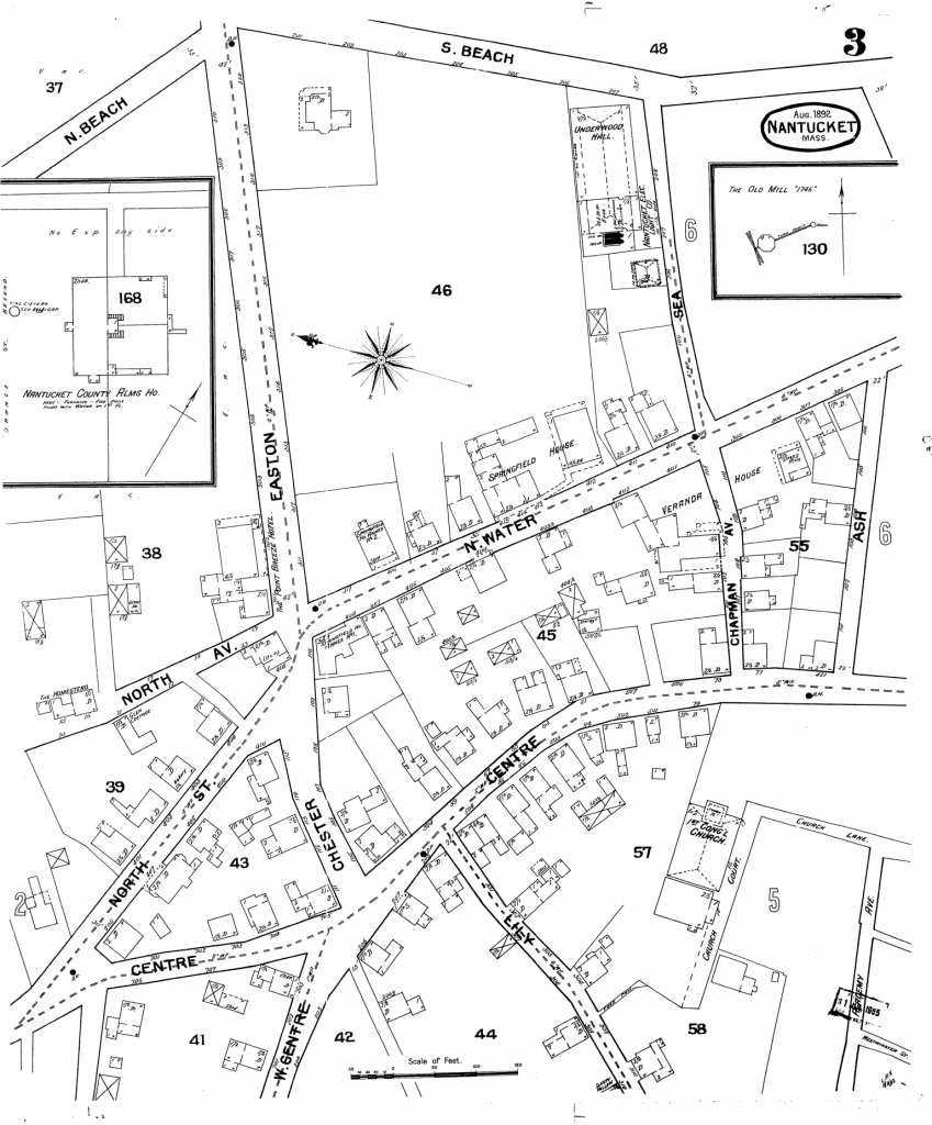
Sheet 3
Sanborn Map of Nantucket, 1892.
Easton Street, Sea Street, North Avenue, North Street (Cliff Road), North Water Street, Chapman Avenue (Step Lane), Ash Street, West Centre Street (West Chester Street), Chester Street, Centre Street, Lily Street, South Beach Street, North Beach Street, church Court, Academy Avenue, Church Lane, Westminister Street. Significant features include First Congregational Church, Veranda House, Nantucket Electric Light Company, Underwood Hall, Point Breeze Hotel, Springfield House. Insets feature the Old Mill, Nantucket County Alms House (Quaise Asylum)
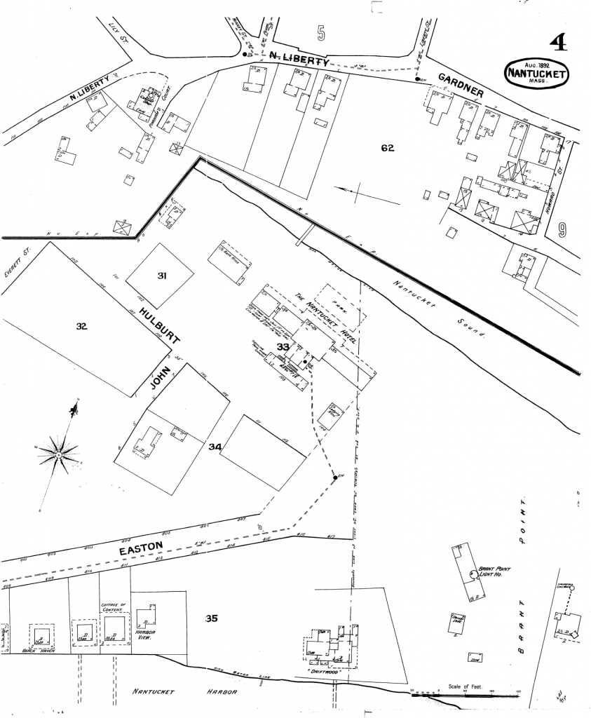
Sheet 4
Sanborn Map of Nantucket, 1892.
North Liberty Street, Gardner Street, Easton Street, John Street, Hulburt Street (Hilbert Avenue). Features include the Nantucket Hotel, Brant Point Lighthouse.
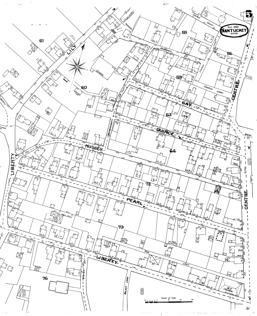
Sheet 5
Sanborn Map of Nantucket, 1892.
Lily Street, Academy Street, Church Court, Centre Street, Church Lane, Gay Street, Quince Street, Hussey Street, Liberty Street, Pearl Street (India Street), Winter Street, Rose Lane, Gardner Street, Walnut Lane, Westminister Street. Features include: Methodist Church, Academy Hill School, Coffin School.
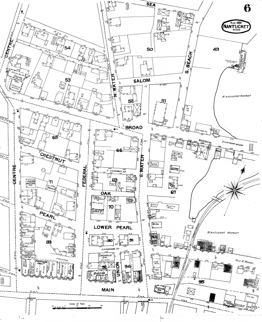
Sheet 6
Sanborn Map of Nantucket, 1892.
Sea Street, Centre Street, Ash Street, Ash Lane, North Water Street, South Beach Street, Salom Street (Whalers Lane), Broad Street, Chestnut Street, Federal Street, East Chestnut Street, Oak Street, South Water Street, Pearl Street (India Street), Lower Pearl Street (India Street), Cambridge Street, Main Street, Liberty Street, Union Street, Old North Wharf, passage (Coleman Lane), passage (Madison Lane), Coal Lane, unnamed (Still Dock, Dock Street). Features include the Atheneum Hall, Public library and museum, Hayden’s Bath Rooms, Ocean House, Friends Meeting House on Centre Street, Catholic Church, Pantheon Hall, Smith’s Hall, Custom House, billards, dentist, photographer, Smith Livery, ice house.
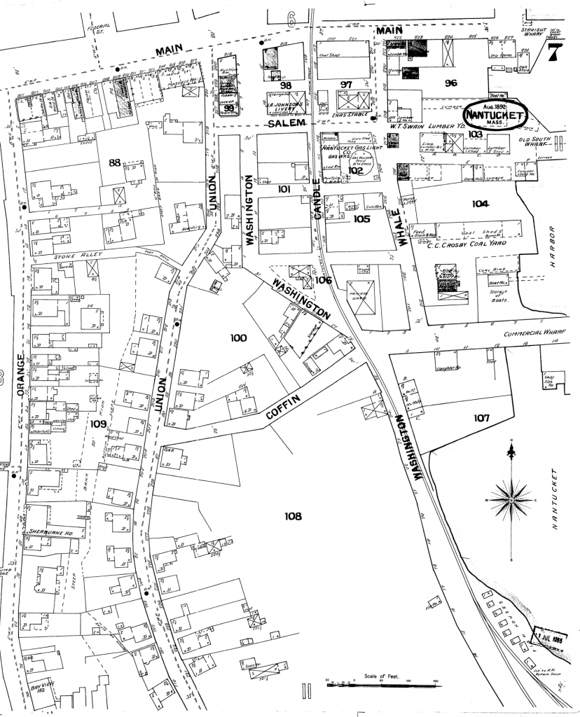
Sheet 7
Sanborn Map of Nantucket, 1892.
Main Street, Salem Street, Union Street, Washington Street, Candle Street, Whale Street, Coffin Street, Orange Street, Stone Alley, unnamed (Gardner’s court), foot of Straight Wharf, foot of Commercial Wharf, foot of Old South Wharf. Features include W.T. Swain Lumber Yard, masonic hall, livery, auction room, C. C. Crosby Coal Yard, fish houses, railroad tracks, Bay View House.
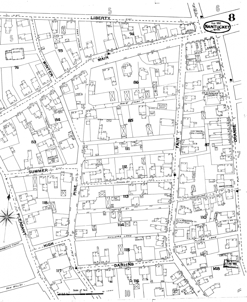
Sheet 8
Sanborn Map of Nantucket, 1892.
Liberty Street, Winter Street, Main Street, Walnut Lane, Traders Lane, Ray’s Court, Orange Street, Fair Street, Pleasant Street, Summer Street, Pine Street, unnamed (Judith Chase Lane), unnamed (Lucretia Mott Lane), School Street, Charter Street, Hullers Lane (Hillers Lane), Darling Street, High Street, Martins Lane, Plumb Lane. Features include St. Pauls Church, Baptist Church, Unitarian Church, American House, C. H. Robinson Carpentry Shop, Homestead (School Street), Friends Meeting House (Fair Street), Coffin School.
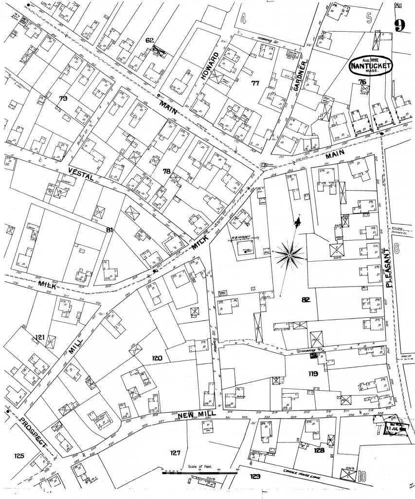
Sheet 9
Sanborn Map of Nantucket, 1892.
Main Street, Howard Street, Gardner Street, Vestal Street, Pleasant Street, Milk Street, Mill Street, New Mill Street, Bloom Street, Risdale Street (New Dollar Lane), Starbucks Court, Candle House Lane, Featured are the House of Correction (Old Gaol), R. B. Hussey Inquirer and Mirror on Milk Street, Sailors monument.
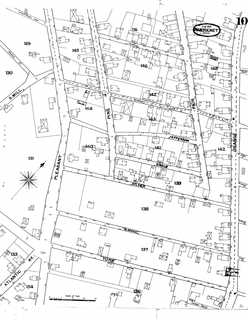
Sheet 10
Sanborn Map of Nantucket, 1892.
Orange Street, Fair Street, Pine Street, Pleasant Street, South Mill Street, Angola Street, Candle House Lane, Farmer Street, Lyons Street (now Lyon Street), Jefferson Street (now Jefferson Lane), Eagle Street (now Eagle Lane), Silver Street, West Dover Street, York Street, Atlantic Avenue, Cottage Court. Unnamed streets include: Boyers Alley, Tattle Court, Twin Street. Features include five corners, Colored Baptist Church (now the African Meetinghouse).
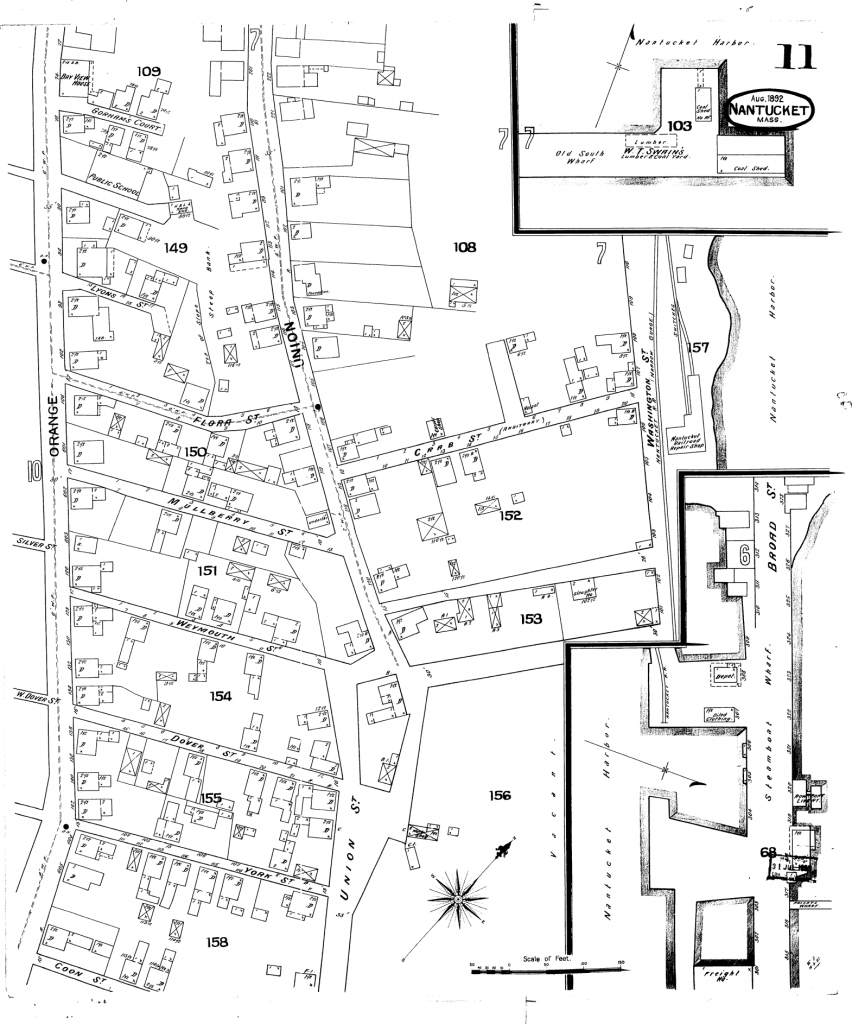
Sheet 11
Sanborn Map of Nantucket, 1892.
Gorham’s Court, Lyons Street (now Cash’s Court), Orange Street, Flora Street, Mullberry Street (now Mulberry Street), Silver Street, Weymouth Street, W. Dover Street, Dover Street (now East Dover Street), York Street, Coon Street, Union Street, Crab Street (now Fayette Street), Washington Street, Broad Street. Features include: Bay View House, Public School, Old South Wharf, W.T. Swain’s Lumber& Coal, Coal Sheds, Nantucket Railroad Repair Shop, Steamboat Wharf, Freight House, Private Wharf, Nantucket Railroad, Oiled Clothing, Rowboat Livery, railroad depot
Credit: Library of Congress, Geography and Map Division, Sanborn Maps Collection.
Sanborn Fire Insurance Map from Nantucket, Nantucket County, Massachusetts. Sanborn Map Company, Oct, 1887. Map. https://www.loc.gov/item/sanborn03800_001/.