
The Sanborn Map® Collection consists of a uniform series of large-scale detailed maps depicting the commercial, industrial, and residential sections of cities. The maps were designed by surveyor D.A. Sanborn in 1866 to assist fire insurance agents in determining the degree of hazard associated with a particular property.
Sanborn Maps® illustrate in outline form the site, size, shape, construction and building material of dwellings, commercial buildings, and factories. Details of buildings include fire walls, the location and number of windows and doors, style and composition of roofs, wall thickness, cracks in exterior walls, and makes of elevators. The maps also indicate building use, sidewalk and street widths, layout and names, property boundaries, distance between buildings, house and block numbers, location of water mains, hydrants, piping, wells, cisterns, and fuel storage tanks.
Library of Congress, Geography and Map Division, Sanborn Maps Collection.
Sanborn Fire Insurance Map from Nantucket, Nantucket County, Massachusetts. Sanborn Map Company, Oct, 1887. Map. https://www.loc.gov/item/sanborn03800_001/.
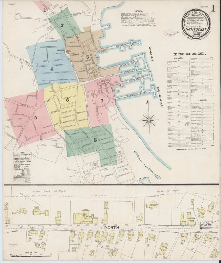
Sheet 1 – index I
Index to Sanborn Maps of Nantucket 1887.
Also detail of North Street (Cliff Road), featuring Sea Cliff House, Manchester Cottage, Outlook House.Note: Water Works owned by private corporation Mains 4 to 8 ins diameter. 33 hydts. Water pressure at RO 37 lbs to the sq inch Fire pressure at RO 80 lbs to the sq inch Reservoir car 50000 gals is filled by a Dluplex Worthington Pump car. 1,5000,000 gals in 24 hours also a smaller Duplex Blake Pump. On an alarm of fire the pumps are started and pump directly into the mains. 3 – two wheel hose jumpers. 2 hook and ladder trucks. 2500 hose in good condition. Fire dept: 46 [?] men, partly paid – all call men.
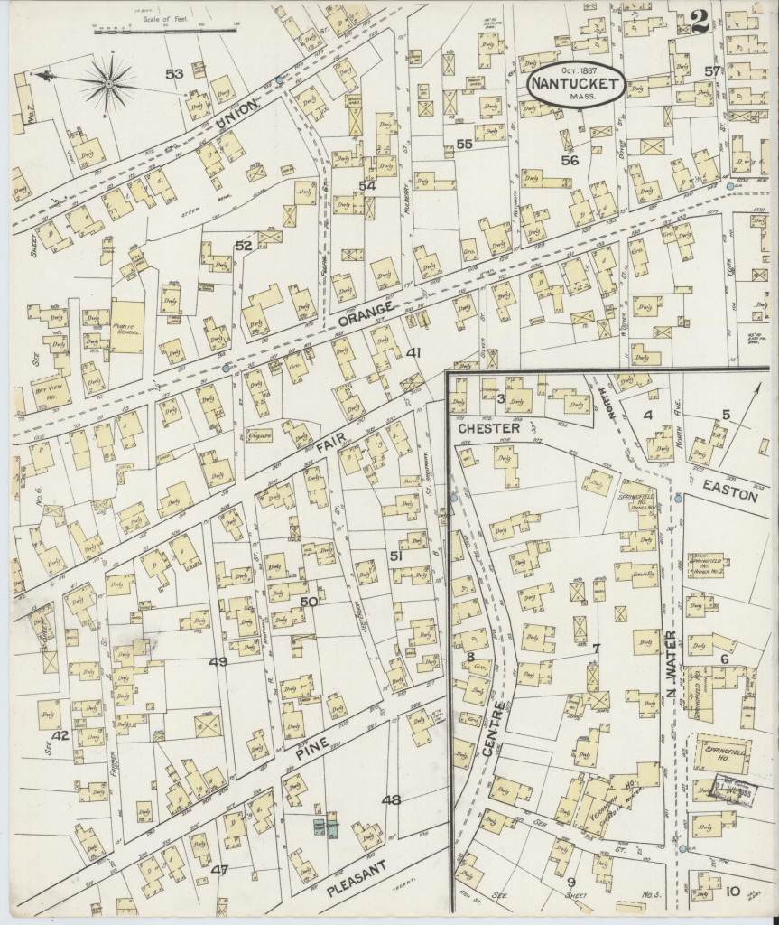
Sheet 2
Map of Nantucket, 1887.
Union Street, Orange Street, Fair Street, Pine Street, Pleasant Street, Chester Street, Easton Street, North Street (Cliff Road), North Water Street, Centre Street, Flora Street, Mulberry Street, Weymouth Street, East Dover Street, York Street, West Dover Street, Jefferson Street, Farmer Street, Ash Street, Sea Street, North Avenue. Unnamed streets include Twin Street, Lyon Street, Gorham Court, Cash’s Court. Includes Springfield House, Veranda House, Orange Street School, Bay View House.
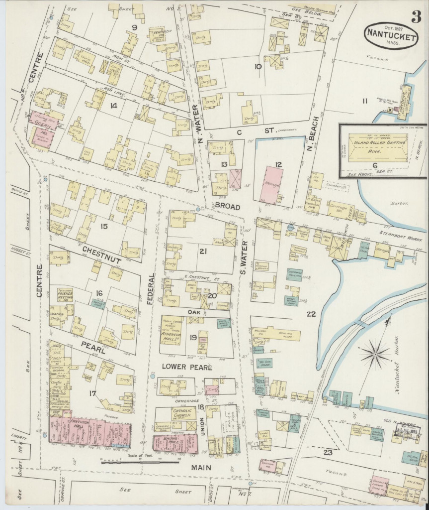
Sheet 3
Sanborn Map of Nantucket, 1887.
Centre Street, North Water Street, North Beach Street, Broad Street, C Street (Whalers Lane), Sea Street, Chestnut Street, Federal Street, Pearl Street (India Street), Lower Pearl Street (India Street), Oak Street, Main Street, Ash Street, Ash Lane, Steamboat Wharf, Quince Street, Hussey Street, East Chestnut Street, Cambridge Street, Liberty Street, Old North Wharf. Includes Island Roller Skating Rink, Hayden’s Bath House, Humane Society, Livery, Wheel wright shop, billiard room, bowling alley, blacksmith shop, Catholic Church, Atheneum, Veranda House, Ocean House, Friends Meeting House, milliner, Turkish Bazaar, Custom House.
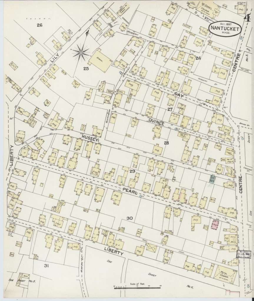
Sheet 4
Sanborn Map of Nantucket, 1887.
Centre Street, D Street (Church Court), Lily Street, Academy Lane, Westminister Street, Gay Street, Quince Street, Liberty Street, Hussey Street, Pearl Street (India Street), Rose Lane, Winter Street. Includes Congregational Church, School, Methodist Church
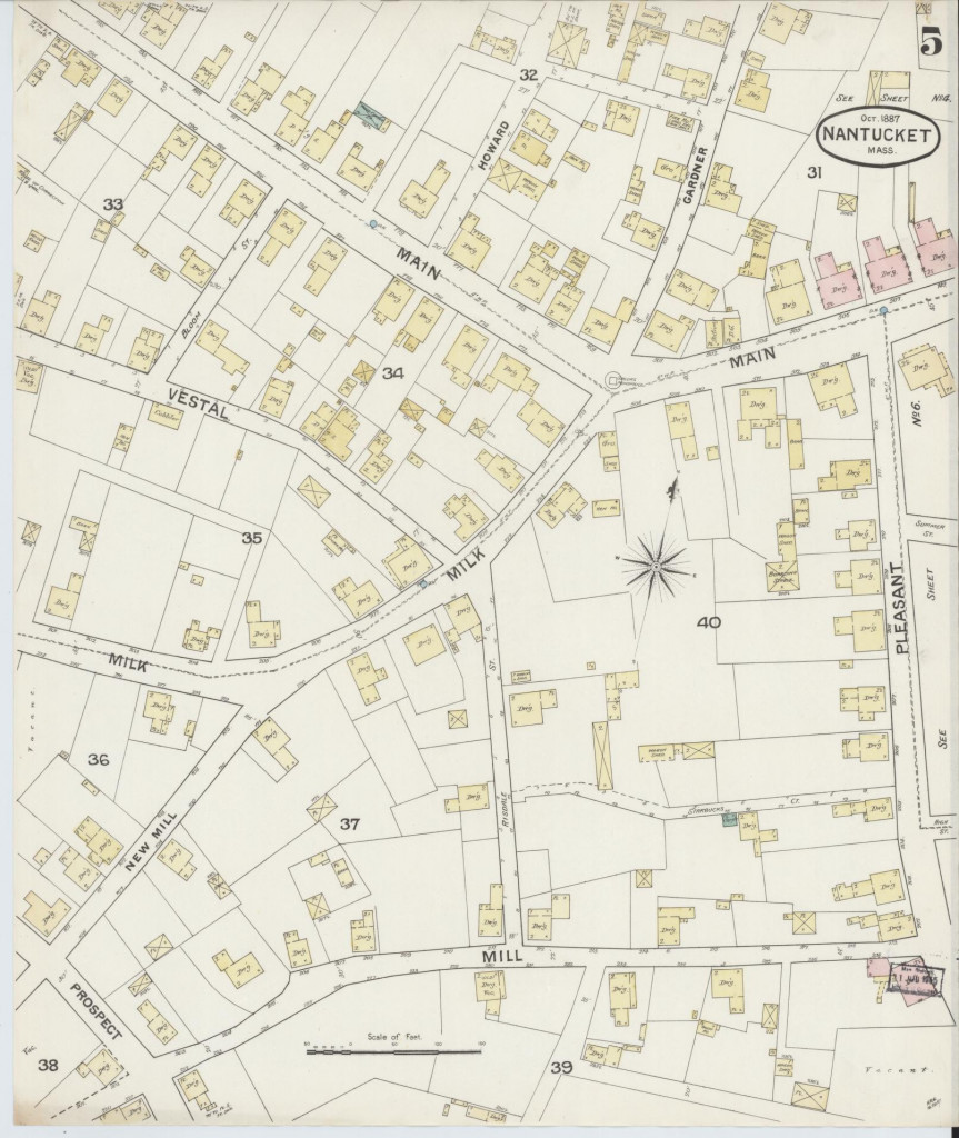
Sheet 5
Sanborn Map of Nantucket, 1887.
Howard Street, Gardner Street, Main Street, Vestal Street, Bloom Street, Milk Street, Pleasant Street, New Mill Street, Prospect Street, Risdale Street (New Dollar Lane), Starbucks Court, Unnamed (Angola Street).
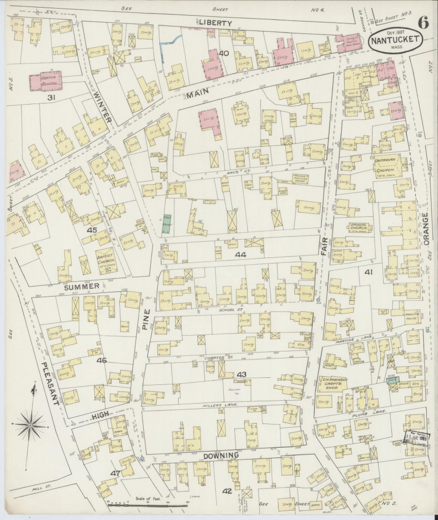
Sheet 6
Sanborn Map of Nantucket, 1887.
Liberty Street, Main Street, Winter Street, Walnut Lane, Orange Street, Fair Street, Rays Court, Pine Street, Summer Street, Pleasant Street, Judith Chase Lane, Lucretia Mott Lane, School Street, Charters Street, Hillers Lane, Downing Street (Darling Street), Martins Lane, Pumb Lane, E Street (Trader Lane), High Street, Mill Street. Landmarks include Coffin School, Unitarian Church, Pacific National Bank, Friends Meeting House, Episcopal Church, American House, C.H. Robinson’s Carpentry Shop, Baptist Church.

Sheet 7
Sanborn Map of Nantucket, 1887.
Main Street square, south side, Orange Street, Union Street, Washington Street, Candle Street, Whale Street, base of South Wharf, base of Straight Wharf, base of Commercial Wharf, Salem Street, unnamed (Gardners Court), Stone Alley, unnamed (Coffin Street). Inset: Nantucket Hotel on Brant Point. Landmarks and significant features include: W.T. Swain Lumber yard, J.A. Johnson’s Livery, gas works, C. C. Crosby Coal Yard, Sherburne Hotel, Bay View House, undertaker, auction room
Credit: Library of Congress, Geography and Map Division, Sanborn Maps Collection.
Sanborn Fire Insurance Map from Nantucket, Nantucket County, Massachusetts. Sanborn Map Company, Oct, 1887. Map. https://www.loc.gov/item/sanborn03800_001/.